You are using an out of date browser. It may not display this or other websites correctly.
You should upgrade or use an alternative browser.
You should upgrade or use an alternative browser.
Places in Brighton that are a mystery to you
- Thread starter The Antikythera Mechanism
- Start date
More options
Who Replied?34064 Fighter Command
New member
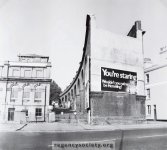
" These three photographs were taken on 28 October 1979, when the scheme for the construction of the new traffic layout at this busy junction had been announced but not started. Such is the delay in getting things commenced nowadays, that it was not until well into 1983, nearly three years later, that demolitions began. First to go were the remains of the Viaduct and the Cox’s offices and works. Then the Vogue Cinema went along with a few of the lower houses in Hollingdean Road. It now remains to be seen whether the impending redevelopment is worth all this upheaval and destruction.
Image Reference: JG_28_064.tif
Date: 1979
Image Details: Original monochrome print
Size of Original: 150x95
Place: Brighton
Additional Information: No comment "
Love the old advert for Hemeling Lager - I have a photo of exactly the same view in 'Rail centres - Brighton' by Basil Cooper but with a different poster for the same beer!
Attachments
Last edited:
glasfryn
cleaning up cat sick
I must say this is one of the best non-football threads I have read since coming on here.
we lived under the viaduct at the bottom of moulecombe way....railway cottages and the only time the trains woke me up was when they were not running (Christmas day ect).
I have found generally that Brighton born people have spread to outlying districts eg: mile oak,portslade,fishergate and to the east, lewes,and there are lots in Eastbourne like myself
34064 Fighter Command
New member
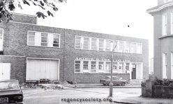
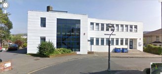
Couldn't resist another 'then and now' comparison, this time of Cox's factory offices on the corner of Richmond Road and D'Aubigny Road.
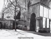
And I don't think I've posted this picture showing a detail of the viaduct with the footpath going through it's separate archway. It claims to show the east side of Lewes Rd. which means the ladies convenience is squeezed between the viaduct and Caffyns ( or maybe they were demolished to make way for Caffyns ? ) The modern views of the area don't really make apparent just how much was squeezed into such a small space.
And I don't think I've posted this picture showing a detail of the viaduct with the footpath going through it's separate archway. It claims to show the east side of Lewes Rd. which means the ladies convenience is squeezed between the viaduct and Caffyns ( or maybe they were demolished to make way for Caffyns ? ) The modern views of the area don't really make apparent just how much was squeezed into such a small space.
Attachments
34064 Fighter Command
New member
Not quite.
If you're heading out of Brighton, the council depot is on the left hand side of the railway line. The 'split' occurs sending the line to the right. It headed down what is now Centenary Industrial Estate and over what is now Sainsbury's.
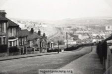
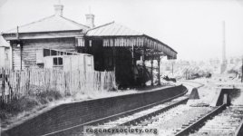
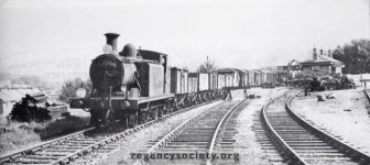
This photo shows both the Lewes line heading towards Falmer on the left and the Kemp Town divergeance at the bottom of Princes Road quite well, plus a couple of views of Lewes Road Station ( the last one with an LBSCR E4 in early logo British Railways livery with BR era rolling stock travelling towards Kemp Town junction and London Road station - the steel mineral wagons indicate this view must be post 1951 ).
Checking my book last night there were unbelievably 17 trains each way on weekdays, and 7 each way on a Sunday between 1883 and 1903 - this obviously pre-dates the private car and the tram system, when the only alternative would have been a horse-drawn omnibus.
I attatch also a copy of the article ' By Rail to Kemp Town ' by R.C. Riley from the December 1952 ' Railway Magazine ' if anyone wants more detail. It's a.pdf file so you'll need suitable Adobe Reader ( or similar ) to read it, but being by Mr. Riley it's accuracy will be impeachable.
Attachments
Last edited:
Wally Gould
New member
- Jul 10, 2011
- 413
The correct name is 'Portslade Old Village'. We lived in Mile Oak in the late 60s and it was always known as that. The area used to get flooded every time there was heavy rain.Portslade Village??!!!!
Never heard of it in all 18 years living in Brighton. My folks
had never heard of it either (moved here in 1968) - until a couple of friends moved
there from London.
Wally Gould
New member
- Jul 10, 2011
- 413
Great pictures. I used to live in St Lukes Terrace in the 50s and I remember hearing the rumble of the trains under the house when it was quiet.This photo shows both the Lewes line heading towards Falmer on the left and the Kemp Town divergeance at the bottom of Princes Road quite well, plus a couple of views of Lewes Road Station ( the last one with an LBSCR E4 in early logo British Railways livery with BR era rolling stock - the steel mineral wagons indicate this view must be post 1951 ).
34064 Fighter Command
New member
I must say this is one of the best non-football threads I have read since coming on here.
we lived under the viaduct at the bottom of moulecombe way....railway cottages and the only time the trains woke me up was when they were not running (Christmas day ect).
I have found generally that Brighton born people have spread to outlying districts eg: mile oak,portslade,fishergate and to the east, lewes,and there are lots in Eastbourne like myself
Not only is this a great trip down memory lane for me but I'm also getting to know the Elm Grove / Lewes Road area as well, not normally frequented by myself as my route from the College to Brighton Station went along Sutherland Road - Freshfield Way - Freshfield Road ( well more across the grassy knoll I've mentioned ) - Eastern Road - Edward Street - Egremont Place - Queens Park Road - Sussex Street - Ashton Rise - Richmond Parade - Grand Parade - Trafalgar Street. The view of the Star In The East pub coming down the hill from the traffic lights at the top of Edward Street ( not to mention the traffic tailback that the sudden convergeance of 4 lanes into 2 at that point caused ) on my way into school is etched into my head as if it were yesterday.
Last edited:
Horton's halftime iceberg
Blooming Marvellous
Couldn't resist another 'then and now' comparison, this time of Cox's factory offices on the corner of Richmond Road and D'Aubigny Road.
And I don't think I've posted this picture showing a detail of the viaduct with the footpath going through it's separate archway. It claims to show the east side of Lewes Rd. which means the ladies convenience is squeezed between the viaduct and Caffyns ( or maybe they were demolished to make way for Caffyns ? ) The modern views of the area don't really make apparent just how much was squeezed into such a small space.
I walk the dog most nights past the new offices (middle picture) most night when the dog has his last outing. After reading some of your posts and links yesterday it suggested their was a gap in D'Aubigny Road where the track ran through, although I am struggling to picture where, I imagine the track ran around the back of these buildings and perhaps they were built on the site of the old halt/station buildings.
Their is an excellent walk you can do around my neighbourhood with the Roundhill History group, they cover the old windmill that stood behind Roundhill pub, the laundrys, the old sylvan estate that our flats are built on, the hidden villa built in the old nurseries, the golf ball, pill factories and the old railway line. I am sure they implied entrance to the station was from a path between the houses between D'Aubigny Road and Richmond Road.
Its amazing how much this area has changed over the years, real big demolition and reconstruction. Loving the old photos.
Horton's halftime iceberg
Blooming Marvellous
If you can't do the tour and like a book, the Rose Hill to Roundhill one is very good, I see they have one on London Road now, so will have to get myself a copy
Local History Books
Local History Books
The Large One
Who's Next?
Their is an excellent walk you can do around my neighbourhood with the Roundhill History group, they cover the old windmill that stood behind Roundhill pub, the laundrys, the old sylvan estate that our flats are built on, the hidden villa built in the old nurseries, the golf ball, pill factories and the old railway line. I am sure they implied entrance to the station was from a path between the houses between D'Aubigny Road and Richmond Road.
Another before and after shot - this one of the windmill.
The owners - none other than the Cuttress family.


34064 Fighter Command
New member

Here was something I knocked up a couple of years ago when I was researching the station, similar to your pic but shows the modern day area around it.
Also included the Hartington Road, Lewes Road and Hollingdean Road area showing where the tracks used to go into what is now the council depot
Fantastic, the Grassy Knoll on the corner of Freshfield Rd. has reappeared, and as I suspected Eastern Rd. has been widened a little to ease that awkward bottleneck. Not only that but the Lewes Rd. map demonstrates why Richmond House has it's peculiar footprint and I can see the footprint of the Vogue Cinema. The railway literally ran right up to the rear of the premises and is now covered by the Centenary Industrial Estate. Who would believe now that a coal yard and railway station once stood here.........
Attachments
Great thread. If Vicente reads this, he'll be back like a shot.
Until recently, you could still see the light railway tracks going into the council depot as they passed over Hollingdean Lane. I think all the building work for the waste transfer station might have removed their final traces though? They were also still visible inside the council depot as well
showing where the tracks used to go into what is now the council depot
Until recently, you could still see the light railway tracks going into the council depot as they passed over Hollingdean Lane. I think all the building work for the waste transfer station might have removed their final traces though? They were also still visible inside the council depot as well
34064 Fighter Command
New member
I walk the dog most nights past the new offices (middle picture) most night when the dog has his last outing. After reading some of your posts and links yesterday it suggested their was a gap in D'Aubigny Road where the track ran through, although I am struggling to picture where, I imagine the track ran around the back of these buildings and perhaps they were built on the site of the old halt/station buildings.
Their is an excellent walk you can do around my neighbourhood with the Roundhill History group, they cover the old windmill that stood behind Roundhill pub, the laundrys, the old sylvan estate that our flats are built on, the hidden villa built in the old nurseries, the golf ball, pill factories and the old railway line. I am sure they implied entrance to the station was from a path between the houses between D'Aubigny Road and Richmond Road.
Its amazing how much this area has changed over the years, real big demolition and reconstruction. Loving the old photos.
Having studied Gary Leeds's map in close up it appears that's right, in fact Richmond House's car park behind the building (on it's north side) is (or is on top of) the last vestigial part of the east end of Lewes Station Platform. The track bed actually runs along the slope behind the car park wall, ( it must have been built back up to the level of the Centenary Ind. Estate back then ) whilst the original railway embankment slope is on the footprint of Sainsburys delivery access road - so this road was excavated out of the railway embankment when Sainsbury's was built. Hughes Road in front of the Industrial units would have been the site of the coal yard, and the Station itself would have been accessed right on the corner of Richmond Rd. and D'Aubiigny Rd. to the left of the 'new' offices .
Lewes Rd. Station building actually sits directly on Hughes Rd. itself, just east of the Amplicon building ( unit 11 ) where the road has been excavated out of the embankment and the West end of the station platform lies somewhere beneath Amplicon and Autoglass ( units 11 and 10 respectively ).
34064 Fighter Command
New member
If you can't do the tour and like a book, the Rose Hill to Roundhill one is very good, I see they have one on London Road now, so will have to get myself a copy
Local History Books
Funny that they mention how by the 1830's the area had lots of laundries, apparently Brighton Piano Centre in Bonchurch Road is located in an old Wash House - just goes to show that there is history all over the place if you know what to look out for.
Two from me:
- right at the top of Queensway at the junction with Freshfield Rd theres some sort of marker stone on the pavement saying, I think. 'Race Hill'. What's it for?
- Selbourne Road, Hove, has a rectangle patch of cobbles in the middle of the road. Why?
- right at the top of Queensway at the junction with Freshfield Rd theres some sort of marker stone on the pavement saying, I think. 'Race Hill'. What's it for?
- Selbourne Road, Hove, has a rectangle patch of cobbles in the middle of the road. Why?
Last edited:
Horton's halftime iceberg
Blooming Marvellous
Funny that they mention how by the 1830's the area had lots of laundries, apparently Brighton Piano Centre in Bonchurch Road is located in an old Wash House - just goes to show that there is history all over the place if you know what to look out for.
Yes these were the outskirts of town prior to washing machines so, Rose Hill up to the back of Cresent Road were used for Landry's as they were on hills - downland, you can still see the layouts behind some of the buildings. Upper Lewes Road was nurseries for plants and behind on the slopes behind orchards. Their is still a big Laundry around Cobden Road - Islingwood Road so they must have used that hill for drying the towns dirtys as well.
As my dog likes a wander around Richmond House car park of a night, it explains the really steep banks down to Hollingbury Road i.e Railway embankment. They are currently building a block of flats on the old Coal depo that used to be an Esso garage.
Gary Leeds
Well-known member
- May 5, 2008
- 1,526
I know the old google maps images for the Hollingdean depot still showed the wall and route of the tracks from the main line.
Its amazing to think that the sole purpose of the Kemp Town line was to stop another train company from having an access route into Brighton. Before it was built there was plans for a second terminus in the Old Steine area (I think) but the Kemp Town spur basically put paid to that. The service went into decline around the war years when the service was suspended and the tunnel was used as an underground bunker (oh god, not another one lol) to store the Brighton Belle rolling stock. During that time all the passengers found the trams were quicker and never came back when the service resumed after the war
A good free source of old maps is Old-Maps - the online repository of historic maps - home page where you can pick a point and then load up maps going right back to the late 1800s. you can even view the maps the Russians took of England when the Cold War was in full flow. I have been grabbing images and then overlaying on Google Earth and it can be amazing to see how much (or how little) an area has changed in 150 years.
And not sure if it has been mentioned but there is still one bit of the foundations of the Lewes Road viaduct still present in the industrial estate car park. Probably the only other remnant of the line apart from the tunnel itself
34064 Fighter Command
New member
Two from me:
- right at the top of Queensway at the junction with Freshfield Rd theres some sort of marker stone on the pavement saying, I think. 'Race Hill'. What's it for?
- Selbourne Road, Hove, has a rectangle patch of cobbles in the middle of the road. Why?
They are boundary stones marking the boundary of the Race Course by all accounts. Originally the course itself was unenclosed and stretched 1 mile 1,585 yards in a hairpin across Race Hill to Bear Road and back. The area known as the Race Ground was granted to the town on 22 April 1822 by T.R.Kemp, Charles Scrase and a number of other landowners, and in 1861 was marked with a series of boundary stones which may still be found along the course of Whitehawk Road, Haybourne Road and northwards to Bear Road; in the Bear Road cemetery wall; in the walls of the General Hospital and the adjacent reservoir in Freshfield Road; and at the northern ends of Queensway and Whitehawk Hill Road. Each stone bears the numerals '105.0.30', the area of the Race Ground being 105 acres, 0 rods and 30 poles.
Race Hill is of course the hill behind Roedean School, between East Brighton Park and Ovingdean - I ran cross country round there many times and at the bottom of the hill on the Ovingdean side is a battery chicken farm - not only was the stench enough to make you gag, but you were generally up to your ankles in wet chalk marl which just seemed to suck your trainers off your feet.
- Jul 10, 2003
- 26,034
Portslade Village??!!!!
Never heard of it in all 18 years living in Brighton. My folks
had never heard of it either (moved here in 1968) - until a couple of friends moved
there from London.
This is Portslade manor

Manor Lodge

Loxdale

Last but not least, my old youthclub

It's right posh in Portslade Old Village
Last edited: