Got something to say or just want fewer pesky ads? Join us... 😊

[Misc] The Award-winning official "More Snow Tomorrow?" Thread [2023-24 Season]


Papa Lazarou

Living in a De Zerbi wonderland
Jul 7, 2003
18,884
Worthing
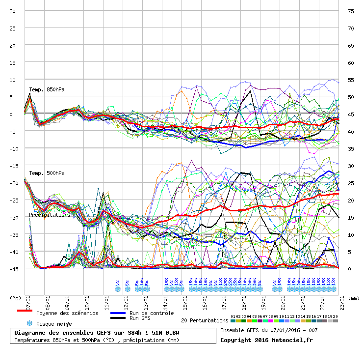
The potential is there for some very cold weather with harsh night time frosts. There will certainly be some snow if these charts verify but precise details are impossible at this stage. The wind direction and strength will be crucial for snow potential in certain locations. A straight northerly favours the north( of course) plus the bits that stick out such as Norfolk, East Kent, West Wales and Cornwall. A Northeasterly which is being shown in some runs favours the North East in particular but also the South East as very cold air becomes volatile over a long North Sea track. More widespread snowfall can also occur in these situations but the features that cause it are often only picked up at short notice.

I hope that helps

And of course, a NE wind, can given certain criteria being met, generate Thames Streamers over our area.

This is basically the same as Lake Effect Snow that they get on the great lakes in the US. The key measure requires a strong airflow of cold air over water that is at least 13C warmer. This allows the air to pick up moisture from the water, which creates heavy snow showers over the coastal areas. Given the right wind direction we have had occasions where a semi-permanent stream of these intense snow showers extend inland from the Thames Estuary down over Sussex.

We've had this a few times in very cold NE winds down here over the years. In fact the winter that started this thread (2010) saw this happen.


edna krabappel

Well-known member
NSC Patron
Jul 7, 2003
47,225


Yoda

English & European
Quite a lot a agreement all the way up until the 16/17 Jan on midnights ensembles:
graphe3_1000_295_174___.gif


BigGully

Well-known member
Sep 8, 2006
7,139
All joking aside this is pure fantasy. The likelyhood is about 6 c by day ie normal and a few frosts. That is it

US you know that many times I am on your side to a point and I accept that the potential for some more seasonal weather just tips out of the more reliable time-frame of say 5 days, but you have to admit the synoptic's offer a likely indication for colder weather, colder than the '6c with a few frosts' on day 6,7 and 8.

Only time will tell if this comes to fruition, but it seems strange on the one hand you dismiss the whole of winter without any particular scientific logic and then disqualify a weather pattern just 7 days downstream because it doesnt fit your earlier unsubstantiated predictions ???

We will see US but all we can do is base any likely outcome on the scientifically generated weather models, surely ?


Papa Lazarou

Living in a De Zerbi wonderland
Jul 7, 2003
18,884
Worthing
The 6Z GFS ensemble shows no sign of a retreat... in fact those early solutions the go straight to mild weather have been removed. Also worth noting, as agreement begins to be reached, the snow % has increased - a good run of 45% to 35% for a couple of days from late on the 16th now.

graphe_ens3_naa2.gif


Flex Your Head

Well-known member
The 6Z GFS ensemble shows no sign of a retreat... in fact those early solutions the go straight to mild weather have been removed. Also worth noting, as agreement begins to be reached, the snow % has increased - a good run of 45% to 35% for a couple of days from late on the 16th now.

graphe_ens3_naa2.gif

Please can you 'demystify' the graph a wee bit?

Do the top set of 'lines' relate to the temperature at 850 metres above ground? So, using the red line (the median), it starts at around 5 degs, but rapidly drops below zero and stays there?

Does the middle set relate to the temperature at 500 metres above ground level? If so, what are they measured against as the figures down the left relate to the temp at 850, and the figs down the right relate to millimetres of precipitation?

The bottom set seem to show the 'depth' of any precipitation in mm. Is that right? If so, the median seems to show minimal amounts.

What do the percentages above the blue snowflakes refer to? The percentage likelihood of snow, or something else?

Finally, what are the blue and black lines?

Sorry for so many questions, but I'm a keen student :eek:)
It might also limit the "But Papa, what does that actually show us though?" questions!


Yoda

English & European
The 6Z GFS ensemble shows no sign of a retreat... in fact those early solutions the go straight to mild weather have been removed. Also worth noting, as agreement begins to be reached, the snow % has increased - a good run of 45% to 35% for a couple of days from late on the 16th now.

graphe_ens3_naa2.gif

:eek: What the hell is going on with that run where the precipitation goes off the chart?


Giraffe

VERY part time moderator
Helpful Moderator
NSC Patron
Aug 8, 2005
26,608
:eek: What the hell is going on with that run where the precipitation goes off the chart?

Some kind of Nuclear fall out, it is unclear whether this is ISIS, the North Koreans or the French.


Albion and Premier League latest from Sky Sports


Top
Link Here