Got something to say or just want fewer pesky ads? Join us... 😊

[Brighton] Brighton & Hove street map.


brakespear

Doctor Worm
Feb 24, 2009
12,326
Sleeping on the roof


symyjym

Banned
Nov 2, 2009
13,138
Brighton / Hove actually

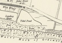
That's quite an interesting website. I can see that the Hove Lagoon was once a tidal pond.

Lagoon.jpg


dejavuatbtn

Well-known member
Aug 4, 2010
7,187
Henfield
Note the detached house in the extreme northeast corner of the site. When was that demolished?
It was always there, fenced off and derelict, at the corner of the ground in the sixties and seventies but I can’t recall when it was finally demolished. Could have been there when the Goldstone went for all I know.


Boys 9d

Well-known member
Jan 3, 2012
1,793
Lancing
That's quite an interesting website. I can see that the Hove Lagoon was once a tidal pond.

View attachment 115207

I understand from very old maps and historical note that before the present Harbour mouth was originally constructed, the River Adur emptied into the sea near the King Alfred.

There seems to be confirmation in that most of the area between the A259 and the beach is a lot lower than either. Over the centuries the river mouth has changed position many times. At one stage it was roughly where the house boats are in Shoreham.


symyjym

Banned
Nov 2, 2009
13,138
Brighton / Hove actually
I understand from very old maps and historical note that before the present Harbour mouth was originally constructed, the River Adur emptied into the sea near the King Alfred.

There seems to be confirmation in that most of the area between the A259 and the beach is a lot lower than either. Over the centuries the river mouth has changed position many times. At one stage it was roughly where the house boats are in Shoreham.

Makes sense. There is quite a drop north side of the promenade. Lower than high tide.


Albion and Premier League latest from Sky Sports


Top
Link Here