Got something to say or just want fewer pesky ads? Join us... 😊

[Misc] The Award-winning official "More Snow Tomorrow?" Thread [2023-24 Season]


Papa Lazarou

Living in a De Zerbi wonderland
Jul 7, 2003
18,858
Worthing
I see it looks like the GFS won the Atlantic/Blocked battle with ECM/UKMO - surprising when you consider the pedigree of them. Back to Atlantic driven weather from next week.
Enjoy the cold weather up to end of this weekend - not sure when it will turn cold again after that.

Interestingly the ECM is sticking with it's establishment of a (probably) temporary Easterly (see the 144 hr chart below)

ECM1-192_hzi8.GIF

The key is (and always has been) how the models deal with a low forming off Canada. The GFS has been continually showing it developing quicker than the other models and moving across the Atlantic quicker. The effect is that the GFS (Op run) stops any ridging northwards of the High Pressure, which other models allow.

This is a good example (ECM - which does develop the ridge and then a Scandi High) - note the 1025MB high to our NNE.

ECM1-144_dsd4.GIF

At the same time, the UKMO looks very similar, which can only be good news (UKMO only goes out to 144 hours for public viewing)

UW144-21_dit2.GIF

Whereas at the same time, GFS is starting to show signs of moving towards the ECM / UKMO solution, but wuth the ridge over the UK and not farther NE.

gfs-0-144_ozm3.png

Within the GFS ensemble (22 of them in total) some DO follow ECM / UKMO and they do develop a transient Scandi High. Perturbation 10 is one - see below

gens-10-1-144_sny1.png

So, what does this mean for us?

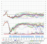
Well, the GFS ensemble for Worthing is below. It shows a couple of cold days (Thurs & Fri) with a chance of snow on the back edge of the front on Thursday (85% chance).

After that there's no sign of a return to very mild conditions with most GFS runs showing temps in the range 0-6C for a while, often under high pressure.

Longer term it will all hinge on how the models develop / or don't High Pressure to our NE.

graphe_ens4_zfr6.gif

For Preston, it's tricky

They will have snow at times Thursday, and possibly Friday. Saturday is the point where the GFS ensemble splits with some colder options in there. If it goes the wrong way, it could see snow, or frost Saturday morning. See edited GFS output below. Worth keeping an eye on for our game

Preston.png
 

Attachments

  • graphe_ens3_svg2.gif
    graphe_ens3_svg2.gif
    53.6 KB · Views: 314
Last edited:


casbom

Well-known member
Jul 24, 2007
2,581
Excellent summary Papa, I heard this morning that at 168hrs the ECM ensembles (all 51 of them) had the Scandi High! And like you say, the GFS is starting to come round. Looks like we might end up with a compromise like we normally do when there is divergence, chances must be for HP to end up over Scotland come this time next week.


Papa Lazarou

Living in a De Zerbi wonderland
Jul 7, 2003
18,858
Worthing
BBC forecast this morning saying rain all day thur for us.

Not that they are ever right as they change it hourly

I wouldn't discount that. NW flows tend to be unkind to us here. If it's cold enough the moisture has gone by the time it gets here (dry) or it's too warm (rain). It has to be spot on (usually with some cold air getting drawn in from the East) to give us snow in this setup. You never know though.

This is the latest Met Office Fax Chart, so created by a human being, using ALL data they can see. That low pressure and tightened isobars approaching the SE could be interesting on Friday, especially if the wind can turn a little more NE

fax84s_wgl8.gif


Papa Lazarou

Living in a De Zerbi wonderland
Jul 7, 2003
18,858
Worthing
Ok, take this with a huge pinch of salt, but the latest 6Z GFS Operational now is in line with the ECM / UKMO at 1pm on Monday, with a ridging High Pressure into Scandinavia. A positive development, which means we have (at least for now!) agreement from all 3 major models on some form of Scandi High.

gfs-0-150_qbb5.png

Therefore, later the GFS Op now looks remarkable like the ECM earlier:

gfs-0-204_cqh4.png

The run hasn't completed yet, so we can't see the ensemble to see how much support the Operational run has in the cluster, which will be very telling.


Papa Lazarou

Living in a De Zerbi wonderland
Jul 7, 2003
18,858
Worthing
I have suggested on the PNE POTG thread that people keep their eye on the weather for possible postponement but have been told there is no worry.

Odds are it'll be ok.

The latest data seems to have removed the sub-zero temp options for Saturday. It'll be somewhere between 2-6C and showery. Sleet / Snow possible. So, it'll FEEL bloody freezing in a 30kmh NW wind.


Thunder Bolt

Silly old bat
I have suggested on the PNE POTG thread that people keep their eye on the weather for possible postponement but have been told there is no worry.

They've got under soil heating but it would be a problem if the approach to the stadium is icy/snowed up.


Driver8

On the road...
NSC Patron
Jul 31, 2005
15,979
North Wales
Over the years I've done most of my skiing in Andorra ( although the last time i skied was ten years ago). I've skiied France, Italy and Austria as well, but i love Andorra ( not just because of the Dury free). I've skiied Arinsal/Pal, Soldeu, Encamp and Pas and they're all great. El Tarter is pretty much Soldeu as it's next door. There's great skiing there , but the whole Gran Valira area is massive.

Enjoy.

I'm looking forward to this


Snowing hard in El Tarter today as predicted. [emoji472] [emoji472]


WATFORD zero

Well-known member
NSC Patron
Jul 10, 2003
25,809
Off the back of your advice Papa, I've now booked a week in La Plagne so it had better be good :wink:

(It's currently snowing and two biggies forecast by Sunday - I fly in Saturday :thumbsup:) )


Papa Lazarou

Living in a De Zerbi wonderland
Jul 7, 2003
18,858
Worthing
Off the back of your advice Papa, I've now booked a week in La Plagne so it had better be good :wink:

(It's currently snowing and two biggies forecast by Sunday - I fly in Saturday :thumbsup:) )

Yes, it looks drier when you're there.... BUT, it's going to be VERY COLD.... just look at the GFS forecast temps

graphe_ens4_rkr1.gif


Papa Lazarou

Living in a De Zerbi wonderland
Jul 7, 2003
18,858
Worthing
Just for fun...

The Latest GFS shows a couple of interesting snow chances here:

12_54_preciptype.png
12_69_preciptype.png


Papa Lazarou

Living in a De Zerbi wonderland
Jul 7, 2003
18,858
Worthing
Papa, Am I right in understanding these are suggesting potential snow for Thursday and Friday?

You are right.

This is just one model, and there is a lot of variance in how the data is being reported, so BBC TV forecasts haven't reflected this yet.

However, as always in these setups, snow events will appear at short notice, once you've got the right conditions in place, which we've not got yet.

A lot can go wrong between now and Thursday....


robinsonsgrin

Well-known member
Mar 16, 2009
1,448
LA...wishing it was devon..
you are right.

This is just one model, and there is a lot of variance in how the data is being reported, so bbc tv forecasts haven't reflected this yet.

However, as always in these setups, snow events will appear at short notice, once you've got the right conditions in place, which we've not got yet.

A lot can go wrong between now and thursday....

go wrong, go wrong, no snow... No snow>


Peteinblack

Well-known member
NSC Patron
Jun 3, 2004
3,612
Bath, Somerset.
From a Facebook 'UK Snow Page', I do hope this materialises :drool:

ECMWF shows a very cold easterly developing in around 10 days time (after this weeks cold snap). No guarantees just yet but the cold weather may be extended. At the moment it is three models vs each other. These models being the ECMWF, GFS and UKMO.
Darker the blue, the colder it is.


Siberian.jpg


Albion and Premier League latest from Sky Sports


Top
Link Here