Got something to say or just want fewer pesky ads? Join us... 😊

Help with a photo


atfc village

Well-known member
Mar 28, 2013
5,012
Lower Bourne .Farnham
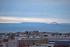
This picture was taken from top of Bear Road and in the centre shows the IOW (sorry if I am stating the obvious). However hat I cannot work out what/where the white cliffs are in the smaller landmass as I thought everything down to Portsmouth was flat. Any thoughts?

View attachment 79619

It certainly looks going from left to right in the picture ,that you are looking at Shanklin and the hills above Luccombe then the back end of St Martins down. The cliffs are Culver down .


Wellesley

Well-known member
Jul 24, 2013
4,973
I saw this post on Facebook too. It's a telephoto lens taking the photo. So you wouldn't see it anything like that with the naked eye. It was an extremely clear day.

Definitely the Isle of Wight.

It's looks just like that with the naked eye.


Wardy's twin

Well-known member
Oct 21, 2014
8,434
Unfortunately and with the greatest respect to skipper734, his evidence is flawed. Portsdown Hill and the Nelson Monument lie almost due West from Bear Road. A direct line between the two passes over land the whole way. Whereas plenty of sea can be seen in your photo between you and the Cliffs in question.

If you draw a line on a map from Bear Road to St Barts Church, then Brighton Station , then extend it out over the sea to the Isle of Wight it ends up at Culver Down. The monument on top is Yarborough Monument.

I am not going to argue with you on this, that was my very first thought but could n't reconcile the gap as land when it looks like sea but I guess the centre of the IOW is quite low. i did think teh cliffs were too white for the bit behind Portsmouth but i have only seen them from a car whizzing past. however thanks to you and skipper734 for your help.


Dick Head

⭐⭐⭐⭐⭐
Jan 3, 2010
13,632
Quaxxann
I'm sure it's not but it looks like a fake photo to me.

What zoom lens were you using? ��

What makes you think that?

red-funnel.jpg


BHAFC_Pandapops

Citation Needed
Feb 16, 2011
2,844
the white down the bottom is mist, surely?


wolfie

Well-known member
Jul 19, 2003
1,663
Warwickshire
If that is really the IoW you must have a bloody good camera - in which case the cliffs are obviously Ballard Down at Swanage - the continuation of the chalk outcrop of the Needles.


Garry Nelson's Left Foot

Well-known member
Jul 7, 2003
13,118
tokyo
This might be(probably is) a really dumb question but...if the Isle of wight is 40 odd miles away and can be seen from Brighton, how come you can't see France which is also 40 odd miles away? Or can you and I just never noticed it?


skipper734

Registered ruffian
Aug 9, 2008
9,189
Curdridge
Calculater for the hard of thinking. Do the maths. Top of Longhill Road Woodingdean is about 200 Mtrs. Cliffs above Shanklin 234 Mtrs. Fort Southwick (Suzick round here)130 mtrs, about 50 Miles away.

http://members.home.nl/7seas/radcalc.htm


Driver8

On the road...
NSC Patron
Jul 31, 2005
15,978
North Wales
The closest distance to France from Brighton is 73 miles.

I can see the mountains of the Lake District from my house on a clear day and that is over 70 miles away as the crow flies.

My house is about 800ft altitude and of course the mountains are somewhat higher than the coast of France.


Albion and Premier League latest from Sky Sports


Top
Link Here