You are using an out of date browser. It may not display this or other websites correctly.
You should upgrade or use an alternative browser.
You should upgrade or use an alternative browser.
[Misc] The Award-winning official "More Snow Tomorrow?" Thread [2023-24 Season]
- Thread starter Giraffe
- Start date
More options
Who Replied?Papa Lazarou
Living in a De Zerbi wonderland
Brighthelmstone
Well-known member
Which airport are you flying into?
Heathrow, then driving down to Bugs Hill
Midfield Minton
New member
- Dec 18, 2013
- 266
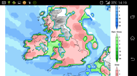
This is the latest GFS precipitation type forecast for 6am Thursday. Note, sleet right on the coast
View attachment 62230
Don't take this as a solid forecast, just yet. Plenty could change
So would that latest show a high chance of snow all over the country
driller
my life my word
Snow days this week or cold rain?
chucky1973
New member
Any updates on the weather chaps. latest models showing improved chances of snow ?
?
 ?
?LamieRobertson
Not awoke
Looking at the country file forecast...bitingly cold wind from about wednesday and they are seeing the possibility of snow at end of week..but aren't certain
brightonwarrior
New member
- Jan 25, 2015
- 10
Hopefully it snows but I can't see it myself!
carteater
Well-known member
I did notice a slight dusting of snow about a week ago in lancing about a week ago when I woke up. The only event so far this winter. Cant remember anything last year either. Maybe 2 years ago for the last big snow event in Sussex.
it has to be march 2013 when the last big snow event happened down here, we are due one, and next week is looking good for one at the moment.
Great stuff. I almost forgotten what it looks like.it has to be march 2013 when the last big snow event happened down here, we are due one, and next week is looking good for one at the moment.
Papa Lazarou
Living in a De Zerbi wonderland
it has to be march 2013 when the last big snow event happened down here, we are due one, and next week is looking good for one at the moment.
This morning's runs maintain the cold theme from Wednesday night through to the weekend. Always bear in mind, down here a Northerly or NW wind isn't ideal for snow.
Let's wait until Wednesday and see how the real synoptics develop.
There is still a lot of variability in the exact details, such as air temps, dew point temp and areas of precipitation.
chucky1973
New member
Hmmmmmmm

you need to charge your phone.
Papa Lazarou
Living in a De Zerbi wonderland
Ok, so we're a little closer to the 'cold spell' later this week.
It all starts late on Wednesday as much colder air digs in behind a cold front that will clear East during the late afternoon.
Following this there is a chance that Sussex will see a period of snow overnight.
Firstly I need to point out that a Northerly is never ideal for snow down here, and we need disturbances in the flow for snow to penetrate this far South, so please don't treat this as a definitive forecast, more a view onto the current trends and where we might go. It's still perfectly possible that we'll just get cold sunny days and frost at night.
The chart below shows the period overnight into Thursday with upper temps just cold enough across the ensemble suite, (red circles) with decent snow percentages:
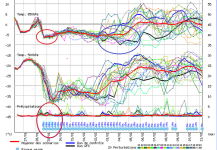
What it also shows is a split in the model predictions from about Feb 2nd (blue circle), where me might get an extended cold spell, or a return to milder conditions
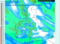
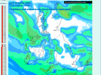
The next 2 pictures show the projected precipitation for the 1am to 7am period. So, there is still lots of potential. We'll know nearer the time if this really does produce snow.
It all starts late on Wednesday as much colder air digs in behind a cold front that will clear East during the late afternoon.
Following this there is a chance that Sussex will see a period of snow overnight.
Firstly I need to point out that a Northerly is never ideal for snow down here, and we need disturbances in the flow for snow to penetrate this far South, so please don't treat this as a definitive forecast, more a view onto the current trends and where we might go. It's still perfectly possible that we'll just get cold sunny days and frost at night.
The chart below shows the period overnight into Thursday with upper temps just cold enough across the ensemble suite, (red circles) with decent snow percentages:

What it also shows is a split in the model predictions from about Feb 2nd (blue circle), where me might get an extended cold spell, or a return to milder conditions
The next 2 pictures show the projected precipitation for the 1am to 7am period. So, there is still lots of potential. We'll know nearer the time if this really does produce snow.


Lyndhurst 14
Well-known member
- Jan 16, 2008
- 5,128
NYC expecting 12 - 18" of snow tonight / tomorrow. My company has just declared a snow day tomorrow
Publius Ovidius
Well-known member
So long as it is ok for Saturday...February medal!
chucky1973
New member
Ok, so we're a little closer to the 'cold spell' later this week.
It all starts late on Wednesday as much colder air digs in behind a cold front that will clear East during the late afternoon.
Following this there is a chance that Sussex will see a period of snow overnight.
Firstly I need to point out that a Northerly is never ideal for snow down here, and we need disturbances in the flow for snow to penetrate this far South, so please don't treat this as a definitive forecast, more a view onto the current trends and where we might go. It's still perfectly possible that we'll just get cold sunny days and frost at night.
The chart below shows the period overnight into Thursday with upper temps just cold enough across the ensemble suite, (red circles) with decent snow percentages:
View attachment 62266
What it also shows is a split in the model predictions from about Feb 2nd (blue circle), where me might get an extended cold spell, or a return to milder conditions
The next 2 pictures show the projected precipitation for the 1am to 7am period. So, there is still lots of potential. We'll know nearer the time if this really does produce snow.
View attachment 62268
View attachment 62269
silly question Papa but is the white in the bottom 2 pics snow? and then the blue and green milder, Rain?
Papa Lazarou
Living in a De Zerbi wonderland
silly question Papa but is the white in the bottom 2 pics snow? and then the blue and green milder, Rain?
The background colour represents intensity, and the hatching colours show non-rain. White = snow Red=freezing rain (none shown). Not sure how they show sleet though.
Midfield Minton
New member
- Dec 18, 2013
- 266
Just enough to not drive to London will be fine
Papa Lazarou
Living in a De Zerbi wonderland
Just enough to not drive to London will be fine
Broadly, as you move away from the Channel the odds of snow in the early hours of Thursday increases, so London has better conditions(as in dewpoint and air temps) with the only caveat being that the little feature that is modelled as causing the precipitation looks like it may pass through Southern England , so there is a northern limit to it's influence.
The latest output still shows a good chance for snow down here early Thursday, diminishing into Friday as a small remnant of a warm sector passes over the UK. If , as some output is suggesting the cold spell continues into next week, we may see colder air drawn into the mix.

